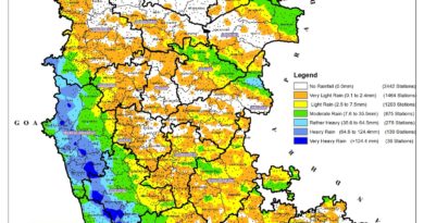
‘Anti-Cyclone’ over Arabian Sea – break in monsoon activity
According to latest update from India Met Department (IMD) on Monsoon activity is said Monsoon flow has been slow down due to formation of anti-cyclone or high-pressure area over the North Arabian Sea.
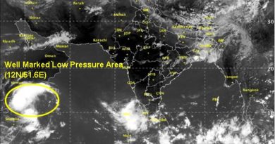
Latest Satellite image released by IMD showed this anti-cyclonic activity , An intense cloud banks across the Arabian Sea and the Bay of Bengal have broken up signaling a break in the monsoon activity.
Monsoon activity to resume in two days
On monday , IMD update said, he monsoon is expected to emerge out of the break soon with helpful cyclonic circulation in Bay of Bengal by Monday. This cyclonic circulation would help monsoon to reach across South Arabian Sea and around the South Indian Peninsula over the next two to three day.
An untimely anti-cyclone (high pressure region that repels monsoon flows) is still dominant over the Arabian Sea, and it would take at least the next week before it breaks down and gives way for the monsoon.
The monsoon usually enters Sri Lanka by May 25, the last outpost before it races across the Laccadives Sea to drive into Kerala on mainland India around June 1. The onset date announced this year by the IMD is May 30, plus or minus four days.
Source: